

Waterfalls of Llacanora
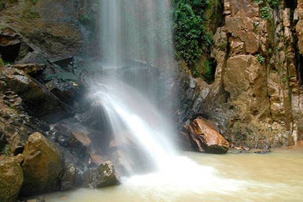
Two waterfalls in the Andean landscape near Cajamarca: The Cascada Hembra and the 30-meter-high Cascada Macho can be reached via short footpaths.
Travel conditions today at the Waterfalls of Llacanora
Weather for Llacanora, travel recommendations, and Perusino's tip. Conditions along the route may vary depending on altitude.
Weather today
The current conditions for Llacanora are being retrieved.
Live update active.
Consider weather and time of day.
Plan your activities according to temperature, rain, and sunlight.
Visit at a glance
- Region
- Cajamarca, Llacanora District
- Best time to visit
- April to November; waterfall is more powerful in rainy months
- Visiting hours
- MINCETUR: 9 am–4 pm; PROMPERÚ: 8 am–6 pm. Confirm on-site.
- Arrival
- 13 km from Cajamarca; 650–740 m walk from Llacanora
- Main route
- Cajamarca → Llacanora → Cascada Hembra and Cascada Macho
Source: MINCETUR, Inventario de Recursos Turísticos, file 6248; PROMPERÚ, Cajamarca – Guía práctica para el viajero.
Places and experiences
Overview of the Waterfalls of Llacanora
The waterfalls of Llacanora are located about 13 kilometers southeast of Cajamarca in the Andean landscape of Northern Peru. Two waterfalls, the Cascada Hembra and the Cascada Macho, are fed by the waters of the Quebrada Shaullomayo. The smaller waterfall is about twelve meters high and cascades over the rock in two stages. The Cascada Macho reaches about 30 meters and forms a much higher wall of water. Both are at an altitude of approximately 2,616 meters and can be reached from the village of Llacanora via short footpaths.
The waterfalls are suitable for a half-day excursion from Cajamarca. The drive there already leads through a rural landscape with fields and small settlements. From the village square, it is about 650 meters to the Cascada Hembra and about 740 meters to the Cascada Macho. The paths are short but traverse natural terrain and can become slippery when it rains.
Location & Arrival
The Cascada Hembra and Cascada Macho waterfalls are located near Llacanora, southeast of the city of Cajamarca. To get there, you first head to the town of Llacanora. From there, you reach the waterfalls via local footpaths. Trails can be slippery in rainy weather.
1. From Cajamarca to Llacanora
Travel by taxi or local transport to the village of Llacanora. The village square is a convenient starting point for the subsequent walk.
Directions on the map2. Cascada Hembra
From the village, follow the local path to the waterfall. Check the route and conditions on-site.
Cascada Hembra on the map3. Cascada Macho
The second waterfall is accessible via another footpath. Wear sturdy footwear if it is wet.
Cascada Macho on the mapDetailed map of the Llacanora surroundings; the waterfalls are located east of the village.
Open full mapMap markers serve for orientation; actual footpaths may vary from the digital navigation.
Sights in the region
All sightsCurrent regional news
All newsImage gallery


Why the Waterfalls of Llacanora are special
The charm of the waterfalls lies in the immediate proximity of two very different cascades. The smaller Cascada Hembra spreads its water over two levels and forms shallow natural pools. A few minutes' walk away, the Cascada Macho plunges about 30 meters down a steep rock face. Both features can be compared on a single walk without needing to embark on a long mountain hike.
Eucalyptus trees, ferns, mosses, blackberry bushes, and retama grow around the waterfalls. With a little patience, birds such as thrushes and hummingbirds can be observed. The rocks and vegetation change their appearance depending on the season: during the rainy months, the waterfalls are more powerful, while the water volume decreases significantly during prolonged dry periods.
Tour of Cascada Hembra and Cascada Macho
The starting point is the main square of Llacanora. From there, follow the local paths towards the waterfalls. A footpath approximately 650 meters long leads to the Cascada Hembra, taking about ten to fifteen minutes according to the official tourism inventory. The waterfall is about twelve meters high and is distributed over two levels. Especially when water levels are sufficient, it is worth looking at the different currents and the vegetation on the rock.
To get to the larger Cascada Macho, it is about 740 meters and approximately 15 minutes on foot from the village square. Its 30-meter-high drop is particularly impressive after rainfall. For both destinations, including photo stops and the return journey, half a day is a relaxed schedule. The actual route should be checked on-site; a digital map does not replace signage.
Events in the region
To the calendarNature, landscape, and formation
The water of both cascades comes from the Quebrada Shaullomayo, a stream in the vicinity of Llacanora. Rocks of varying resistance and natural erosion characterize the rock walls over which the water flows. The Cascada Hembra falls over two smaller steps, while the Cascada Macho plunges down a high rock face into the depths.
The landscape is located in the Quechua altitude zone of the Peruvian Andes. The mix of rocky areas, moisture near the water, and drier slopes creates different habitats for plants. The official tourism inventory mentions eucalyptus, retama, ferns, mosses, as well as wild birds and smaller mammals. Visitors should respect the vegetation on the paths and leave no trash behind.
Admission and visit
The official MINCETUR tourism inventory lists the waterfalls as a freely accessible natural destination. In contrast, the current travel brochure from PROMPERÚ mentions access with a ticket, without specifying a concrete price. Since these official details differ, a currently binding entrance fee cannot be reliably stated. Visitors should inquire at the access point and, if necessary, take small denominations of cash.
For the journey from Cajamarca, MINCETUR mentions about 13 kilometers or about 25 minutes by minibus to the main square of Llacanora. From there, you continue on foot. No multi-day tour or special Inca Trail permit is required for the two waterfalls. Those who wish to combine the surroundings with other destinations can find suggestions on the Overview of Sights in Northern Peru.
Opening hours and best time to visit
MINCETUR provides a visiting window of 9 am to 4 pm for the waterfalls and recommends the months of April to November. PROMPERÚ, on the other hand, lists daily hours from 8 am to 6 pm in a current travel brochure. These details are not identical. Therefore, for reliable planning, a visit during daylight hours and inquiring about locally applicable times is recommended.
In the rainier months, the waterfalls carry more water and appear correspondingly more powerful. At the same time, paths and rocks can be slippery. During longer dry periods, especially in August and September, the volume of water is usually lower. Those who primarily want to photograph the waterfalls should take both sufficient water levels and safe path conditions into account.
Current situation
In the official tourism inventory, the condition of the waterfalls is described as good. The municipality of Llacanora is listed as responsible for the ongoing maintenance of the natural site. This assessment comes from the entry updated at the end of 2024 and is not a daily guarantee for the condition of individual paths or access points.
Heavy rain can increase the water level in the short term and make paths impassable. Especially after prolonged rainfall, visitors should heed local warnings and not enter closed sections. The information on admission and opening hours varies between MINCETUR and PROMPERÚ; therefore, the rules applied locally are authoritative.
Difficulty and accessibility
The footpaths from the village square to the waterfalls are relatively short. However, they are not continuously paved city paths. Uneven stones, gradients, and slippery spots when wet can make the walk difficult. Sturdy footwear with grippy soles is therefore advisable even for a short excursion.
A completely step-free or wheelchair-accessible route to both waterfalls is not confirmed based on available official information. Those who depend on barrier-free access should inquire in advance at the Llacanora municipality about current possibilities. The altitude of about 2,616 meters may also require a slower pace after arriving from the lowlands.
Visit tips
An early start from Cajamarca is recommended for the excursion so there is enough time for the journey, both waterfalls, and the return trip. Useful items include drinking water, sun protection, a light raincoat, and non-slip shoes. Currents and water depth in the natural pools can change depending on rainfall; safe swimming conditions cannot be assumed.
For photos, maintain enough distance from wet cliff edges. Plants and animals are part of the natural environment and should not be disturbed. Those planning further excursions can combine the visit with other destinations in the Cajamarca area; an overview is provided by the collection of sights in Northern Peru.
Accommodation in the region
Affiliate link: The map is loaded by Stay22. PeruMagazin may receive a commission for bookings; the price remains unchanged for you.Keep an eye on current Peru news
Travel tips and important information from Peru in the PeruMagazin WhatsApp channel.
Frequently Asked Questions
How high are the Llacanora waterfalls?
The Cascada Hembra is about twelve meters high, the Cascada Macho about 30 meters.
How far are the waterfalls from Cajamarca?
About 13 kilometers to Llacanora, then about 650 to 740 meters on foot from the village square.
What is the admission fee?
MINCETUR lists free access, while PROMPERÚ mentions entry with a ticket. A current binding price is not confirmed; please check on site.
When can I visit the waterfalls?
Official information ranges from 9 a.m. to 4 p.m. (MINCETUR) to 8 a.m. to 6 p.m. (PROMPERÚ). It is best to visit during daylight hours and observe local times.
Sources
- MINCETUR – Inventory of Tourist Resources of Peru, file 6248: Cascadas de Llacanora, updated December 16, 2024.
- PROMPERÚ – Cajamarca: Practical guide for the traveler, 2026 edition.
- Government of Cajamarca – Tourist map of the province, Llacanora district.
- Image sources: Historia Adventure (Cascada de Llacanora); FotoPaíses (Llacanora); Viajes Premium (Cataratas Llacanora). Image rights belong to the respective creators; reuse not confirmed.


